
Mapping
Advanced drone technology for mapping and aerial survey solutions.

Aerial mapping can take many forms depending on the information or data required.
Spectrum Drone Services owns multiple survey and mapping drones to service your aerial mapping requirements.
We provide drone mapping services to industry:
Agriculture
Construction
Forestry
Mining
Real Estate
Surveyors

Multirotor Mapping
Multirotor drones are a very good platform for mapping smaller geographic areas or obtaining 3D imagery of a single object in a single flight. Our expertise in operating unmanned aircraft in complex environments means we can deliver.
At Spectrum Drone Services we currently use four different types of multirotor drones for aerial mapping depending on the task and the required product. We use state-of-the-art drone technology combined with powerful industrial mapping software.

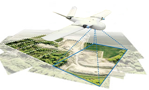
Fixed Wing Area Mapping
At Spectrum Drone Services we use three different types of specially designed fixed-wing drones for mapping larger areas due to their increased flight duration and efficiency.
Our specially designed twin engine fixed-wing mapping drones are equipped with the very latest sophisticated flight control system and mapping cameras. This feature packed advanced drone is able to fly for over 2 hours, with a cruising speed of 70kph its ideal for mapping large areas efficiently.
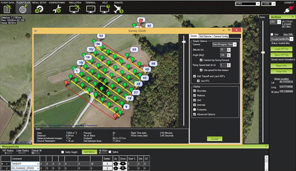
Software Tools for Mapping
The drone is only one piece of the whole process of aerial mapping. Not only does one have to possess excellent airmanship and knowledge of the aircraft and its systems, familiarity with the mapping process and the multiple software packages is essential.
At Spectrum Drone Services we use industry standard hardware, processes and software to ensure we provide you with one thing ... an outstanding product.
2D aerial mapping imagery and 3D terrain models can be used for a multitude of purposes, whatever your requirements call us now to discuss how Spectrum Drone Services can help.
For more information on our photogrammetry survey solutions please visit our photogrammetry services.
Drones for Aerial Survey
Watch this 530am launch of a QuestUAV Q200 survey drone.
This highly capable flying-wing is fitted with state-of-the-art autopilot and features powerful computer based Ground Control Station mapping software.
At Spectrum Drone Services we use industry leading drone technology.